Best Backroads near Eureka on the California Coast
If you are staying near the coast in Humboldt County and want to find a scenic drive full of remoteness, then we have some suggestions for you. All four of these backroads are near the Northern California Coast and not far from the Eureka / Arcata area.
Most of these roads are suitable for a normal passenger vehicles, but there is one option for those folks with four wheel drive and backcountry driving experience. Two of the drives are near The Lost Coast and the other two explore the mountains east of Humboldt Bay. All of them are fun to drive and take you to places that tourists rarely see.
There’s always a possibility of snow on the roads in the winter months and the dirt roads can be nasty when wet so consider what time of the year you want to go and consult a weather forecast too. Always fuel up your car before starting these drives.
Here are the backroads listed from south to north.
Shelter Cove to Honeydew (2 Options)
Paved or dirt – you choose
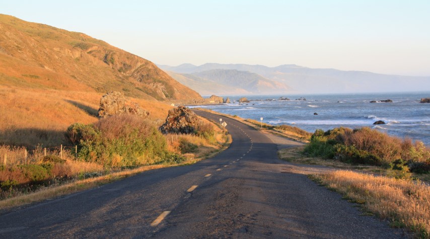
This route starts with a wonderful drive from Garberville to Shelter Cove and one of the top California beaches, Black Sands Beach. From Garberville you’ll drive to nearby Redway and then go west on Briceland Road then Shelter Cove Road 21 forest-filled miles. The coastal town of Shelter Cove is a hidden gem on the Lost Coast.
This town is not a quick stop as it’s too special not to stay a night or two (or more). While you are there you should take a day to drive south to Needle Rock Visitor Center in Sinkyone Wilderness State Park. Hike down to look at Needle Rock Arch for sure and maybe Bear Harbor Beach if you have time. Before leaving Shelter Cove visit Black Sands Beach and walk as far away from town as you are comfortable. This beach is part of the famous Lost Coast Trail.
When you finally leave Shelter Cove you have two choices to drive to Honeydew.
The first is an epic mountain backcountry road called Kings Peak Road. This twisty dirt road follows a high ridge near the coast in King Range National Conservation Area. It begins on the north side of Shelter Cove Road about 1.4 miles from Shelter Cove General Store. After turning onto this road you’ll be on an adventure for at least a couple hours. Since you opted for the rugged dirt road, you might want to take a left at 6.4 miles on Saddle Mountain Road which stays on the ridge before reconnecting with Kings Peak Road (eventually you’ll turn right at an intersection to get back to Kings Peak Road where you’ll go left toward Honeydew). Saddle Mountain Road is rugged and best for high clearance 4WD rigs. Kings Peak Road is a bit milder than Saddle Mountain and stays in the North Fork Bear Creek Valley. Beyond where these two roads reconnect, Kings Peak Road crosses Bear Creek and then climbs quickly on switchbacks back onto a ridge where it T’s into Wilder Ridge Road. Go left on this paved road which leads to Honeydew.
The second option from Shelter Cove to Honeydew is a paved road. It’s not in perfect shape, but it’s not rugged and dusty like Kings Peak Road. To find this road drive east on Shelter Cove Road which becomes Briceland Road. At nine miles from Shelter Cove General Store the Ettersburg Road will start on the left side. Drive this curvy road for 5.5 miles to a bridge over Mattole River and continue a little bit to Ettersburg, a remote farming community that few people ever see. It’s a pretty place but there are no services. Keep driving on the paved road which goes north and becomes Wilder Ridge Road. It meanders for about 13.5 miles from Ettersburg to Honeydew General Store where you should get a treat.
Mattole Road
Paved road
This is one of the best drives on the Northern California Coast and it passes by an amazing beach at the mouth of the Mattole River. Signed for Petrolia, Capetown and Honey Dew, the start of Mattole Road is on Ocean Avenue in Ferndale, a picturesque town near the coast. Follow the road as it ascends and then meanders along forested ridge tops before descending to a river valley where the town of Capetown once stood. It goes up and over one more ridge before reaching Cape Mendocino where a lighthouse once stood (it’s now in Shelter Cove). Mattole Road now follows the ocean shore and has access to the Mattole Road Beaches. Eventually the road goes inland again and leads to the small town of Petrolia (not much there but a general store). Just after crossing a large bridge near Petrolia, turn toward the ocean on Lighthouse Road. This five mile out-and-back option goes to Mattole River Beach and the start of The Lost Coast Trail. Walk out to the beach and camp at the campground if you like.
After visiting the beach head back on Lighthouse Road and turn right onto Mattole Road and follow it all the way to Highway 101. On the way it will pass through Honeydew where the previous backroad tour ends. Note that the last 15 miles of Mattole Road pass through Humboldt Redwoods State Park where you might encounter more traffic. This park has campgrounds and many hiking trails.
When Mattole Road ends at Highway 101 it’s possible to extend your drive by going north or south on Avenue of the Giants.
Eureka to Bridgeville on Kneeland Road
Paved and dirt roads
This backcountry road twists and turns for 45 miles from Highway 101 in Eureka to a rural town with a few homes, a church, and a post office known as Bridgeville. Google Maps says this route will take 2 hours, but it’s a dirt road and you’ll stop a lot along the way.
Start in Eureka and follow Kneeland Road for about 18 paved road miles to Kneeland Airport. This backroad drive continues on Kneeland Road (turns right before the airport) down to Bridgeville on Highway 36. This section of Kneeland road from the airport to Highway 36 is mostly dirt roads.
Other backcountry drives can be found in the area including Mountain View Road which heads east from the airport on dirt roads and eventually comes back to Kneeland Road. Showers Pass Road is another alternate dirt road side loop to Kneeland Road. No matter which of these road you chose to explore, watch for animals, especially cows, on the road.
In Eureka we recommend driving out New Navy Base Road to the end and the sandy beach at Samoa Dunes Recreation Area.
Arcata to Blue Lake (The Long Way)
Mostly paved with 3.5 miles of dirt
This route uses mostly paved backroads that are narrow and unstriped so you’ll have to keep your eyes on the road and watch your speed in blind corners. There are gravel sections on Fickle Hill Road.
In Arcata head east on 7th Street and look for Fickle Hill Road when you are east of Highway 101. Follow this road for 13 miles until it gets to Butler Valley Road, a hard left on a paved road (note that signs west of this intersection point the way for cars going the other way). Go east on Butler Valley Road to where it drops down to and crosses Mad River. Go right after the bridge then look for Maple Creek Road on the left (less than a mile from the bridge). Continue on Maple Creek Road for 13 miles to the Korbel Sawmill and a couple more miles to the town of Blue Lake.
From Blue Lake the most scenic way to get back to Arcata is to take Hatchery Road to West End Road which avoids Highway 299 all the way.
After your drive you should head out to Mad River Beach not far from Arcata.