Best Backroads near the Central California Coast
California’s central coast has backroads that few tourists ever get to see. Sure a drive down the Big Sur Coast is about as good as it gets from a pure driver’s perspective and it has many attractions and endless viewpoints, but there are more roads begging to be discovered.
These roads are not for ripping around in your Porsche. They should be driven slowly and carefully so you can enjoy the scenery. They pass by farms, wineries, country homes, and scenic vistas. Several are dirt roads and can be rough at times so do your research and think about which car you want to drive on them.
This list is was created to help you find great backroads and dusty overland routes near the coast for true road trip adventures.
Santa Ynez Mountains above Santa Barbara
45 miles, pavement & dirt
This route is a real gem. In addition to a road with constant views, there are several landmarks to discover. Note that this one has dirt roads that can be rough at times. If you get to a section that is too rugged for your rig, turn around and head back from where you came.
We suggest starting at Refugio State Beach and driving away from the coast on Refugio Road which soon becomes National Forest Road 5N12. After switchbacks and steep climbs this backcountry route reaches Refugio Pass at over 2200 feet. From there this drive heads east on West Camino Cielo Road which follows the ridge crest and becomes a dirt road on the way to Santa Ynez Peak (4298′) where you should stop and enjoy the view. From there the road gradually descends to Highway 154 near San Marcos Pass. Turn left on 154 and quickly turn right onto paved East Camino Cielo Road. After a while Painted Cave Road turns right and leads to Chumash Painted Cave. In another mile you can take a break and do the short hike out to Knapp’s Castle. Continuing east on Camino Cielo it follows the Santa Ynez ridge crest and reaches the summit of La Cumbre Peak (3985′), another place to stop and check out the view. This road eventually intersects Gibraltar Road the route back down to the lowlands in Santa Barbara.
Santa Rosa Road
17.3 miles, paved
This is a simple drive in a river valley filled with farms and vineyards. Most folks driving from Buellton to Lompoc in Santa Barbara County will take either Highway 246 or Highways 101 and 1. You should take Santa Rosa Road. It follows the Santa Ynez River with bucolic views aplenty. If you plan ahead you can get reservations at several wonderful wineries and this drive, which normally takes less than a half hour, could last all day. If you want more scenic twisty roads then drive down to Jalama Beach and get a burger.
Cayucos to Cambria via backroads
25.3 miles, paved
This is a great way to see a part of San Luis Obispo County that few see. It’s narrow in places so watch your speeds and enjoy the bucolic feel. Start by driving east on Old Creek Road which begins at Highway 1 just south of Cayucos. The road goes inland past Whale Rock Reservoir eventually reaching Highway 46 (Eric Seastrand Memorial Hwy) after 9.1 miles. Cross the highway and continue driving on what becomes Santa Rosa Creek Road. This narrow twisty road continues for 16.2 miles eventually reaching Main Street in Cambria. If you want to extend the trip a bit, turn right and head down Main Street and drive to Moonstone Beach Drive. Park somewhere along the road and walk the boardwalk at Moonstone Beach.
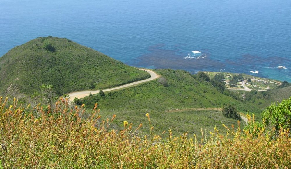
Nacimiento-Fergusson Road
24 miles, dirt
When there are road closures on Big Sur (which happens regularly) this rugged dirt road is the best way to access the middle portion of the Big Sur Coast for those who are cut off. But this road is much more than an emergency bypass. If you are staying on the Big Sur Coast and want to explore the mountains of Los Padres National Forest, Nacimiento-Fergusson Road is your best bet. From where it starts at Kirk Creek Campground on Highway 1 it is about 24 miles to Fort Hunter Liggett where you can turn around or you can turn around sooner if the going isn’t interesting enough for you.
To extend this backcountry drive you can turn south onto South Coast Ridge Road 20S05.4 (if it’s open) which you will find at the crest of the Santa Lucia Range. On that road you can drive 7 miles then turn right to descend to Highway 1 on the Plaskett Ridge Road which ends at Plaskett Creek Campground and Sand Dollar Beach. Or you can continue 8 more miles to Los Burros Road which descends to Highway 1 at Treebones Resort (Glamping) and Willow Creek Beach.
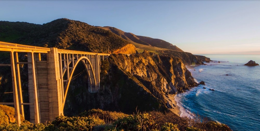
Big Sur’s Old Coast Road
10.2 miles, dirt road
This scenic alternative to the equally scenic Big Sur Highway (Hwy 1) goes from Andrew Molera State Park up into the hills and ends at the iconic Bixby Creek Bridge. Going northward it ascends quickly from Highway 1 and soon offers views of the Pacific coastline, Andrew Molera’s green ridges, and the fields of El Sur Ranch. It reaches an elevation of nearly 1000 feet before descending into the Little Sur River valley. After climbing again it finishes with a long drive down the Sierra Creek valley. Near the end you’ll want to stop and take photos of Bixby Bridge with the ocean behind it.
If you haven’t driven the entire Big Sur coastal highway then do it first of course. We recommend doing that drive in the southern direction (Carmel to Cambria) so it’s easy to turn right at viewpoints. But if you’ve experienced Big Sur’s main route before then Old Coast Road is a great way to mix it up a bit.
Carmel Valley & Salinas Valley Loop
100 miles, paved
Driving just about anywhere near Carmel-by-the-Sea is going to be pretty. If you want an alternative to Highway 1, head east on Carmel Valley Road (G16) as far as you want to go (a great side loop is the Cachagua Road). This gorgeous road eventually becomes Arroyo Seco Road as it approaches the Salinas River Valley and Highway 101. Follow Arroyo Seco Rd (G17) to Fort Romie Road and go left. Stop at Mission Soledad if you have time and then continue as Fort Romie Rd becomes River Road (still G17). This route follows the valley past farms and wineries all the way to Highway 68 near Salinas. Turning left on 68 goes back to Highway 1 in Monterey.
After this drive, head back to Carmel and settle into lovely Carmel River State Beach for the rest of the day.
