The Lost Coast Trail Map
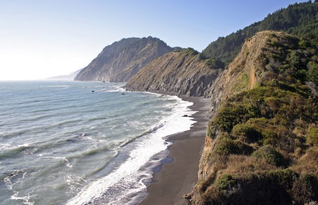
The Lost Coast Trail is a popular summer backpacking route along the most remote shoreline in Northern California. The trail meanders at the foot of high mountains in the King Range of southern Humboldt County and northern Mendocino County.
This terrain is so rugged that no paved roads exist along the shore for more than 50 miles except at Shelter Cove near the midpoint of the trail. The good news is that this route can be broken up into three different segments.
South Lost Coast Trail – Usal to Needle Rock
The southern segment begins at Usal Beach near Westport and meanders north to Needle Rock Visitor Center in Sinkyone Wilderness State Park (22 miles). It’s a rocky steep shoreline here so the trail doesn’t follow the beach. Instead it rises and dips along the foothills with backcountry camps and beach access points along the way. Driving access is via Usal Road off Highway 1 north of Westport.
Central Lost Coast Trail – Needle Rock to Shelter Cove
The middle segment goes north from Needle Rock to the town of Shelter Cove (9 miles). It’s the shortest section and probably the least traveled. The trail climbs up over Chemise Mountain (2598 feet) and ends at a trailhead on the road to Shelter Cove. Driving access is via Shelter Cove Road which starts as Briceland Thorn Road in the town of Redway on Highway 101.
North Lost Coast Trail – Shelter Cove to Mattole
The northern segment starts on Black Sands Beach and continues north to the end at Mattole Beach on the Mattole River (25 miles). This route is probably the most popular as it follows a sandy beach for most of the way. Traveling this path requires timing it to avoid high tide when portions of the beach are all wet and impassable. Driving access is via Mattole Road staring on Highway 101 between Weott and Redcrest.
The map above shows the beaches and camps along the Lost Coast Trail. Below is information you’ll need before planning a hiking or backpacking trip on the trail.
Precautions
- Weather can be windy and damp at any time, even in the summer. Pack accordingly and prepare for the worst.
- Sneaker waves can be deadly. These waves are much larger than normal and can knock you down then pull you into the ocean. Always keep an eye on the ocean and only stop to rest at the upper part of the slope.
- Ticks are common on this entire route and can cause Lyme Disease or other tick-borne illnesses if bitten. Take precautions to avoid bites.
- Rattlesnakes are common too but they are easier to see and hear than ticks. Still watch where you step even when near the beach.
- Bears and raccoons are a problem in campsites so bear canisters are required.
- Poison oak is another common problem. Know how to identify the plant and watch for it everywhere you go.
- Potable water is unavailable in most areas so you must bring water or water purification means and know where water sources are.
Links for more information
The southern half of the Lost Coast Trail is in Sinkyone Wilderness State Park (park map). Read up on the park rules and regulations before your trip.
The northern half is in the King Range National Conservation Area which is administered by the BLM. They have different rules and permit requirements.
For free topo maps of the region, we recommend using TopoZone.
More info on the LCT can be found at the Lost Coast Interpretive Association website.