
Rock arches are some of the most spectacular of Mother Nature’s hand-crafted artwork. The California Coast displays more of these natural pieces of art than any other state. You won’t find any rock arches in the sand of the otherwise stunning sandy beaches of Florida, Texas, or the Carolinas. States such as Oregon and Washington have well-known rock arches too, but not in the sheer quantity that California does. See the full list of beaches with rock arches below.

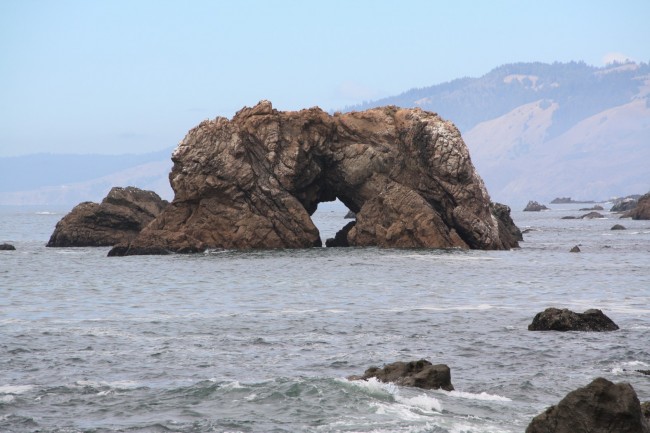
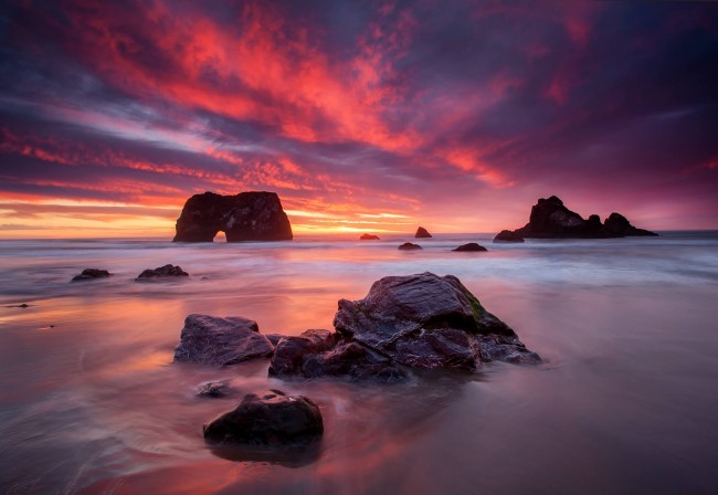
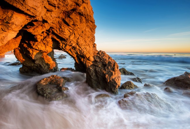
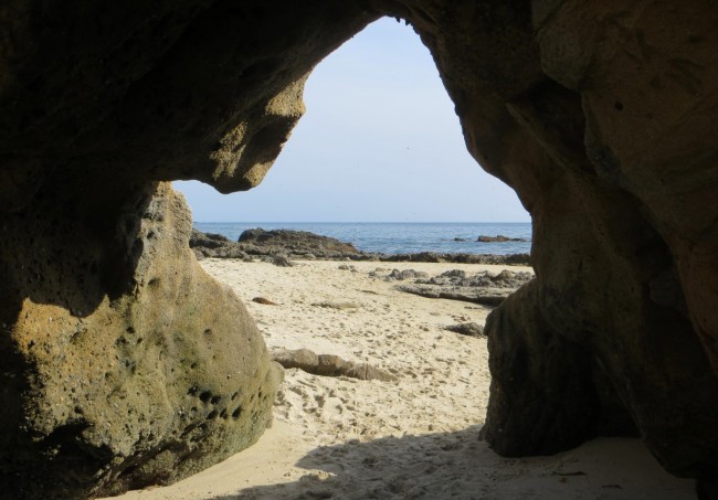
Each rock arch is unique. They vary from huge seastacks with small openings to wide narrow spans to long tunnels. You’ll find such diversity along the shores of California.

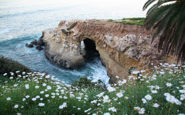
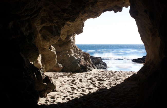
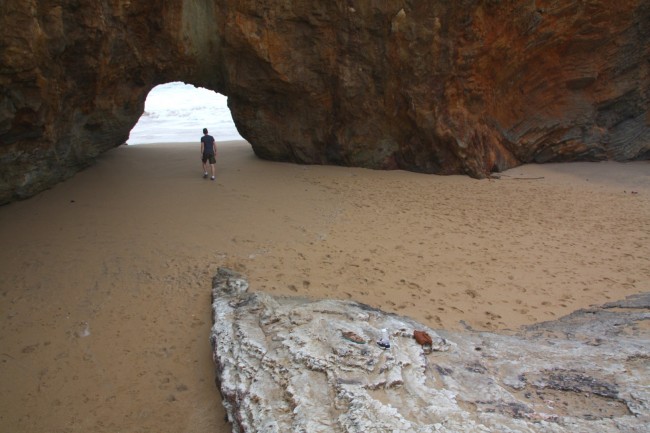
Some are on the beach where visitors can walk right through them. Leo Carrillo State Park has several of these arches, as does El Matador Beach – both of these popular beaches are on the Malibu Coast. The arch at Seaside Beach in Fort Bragg leads to a hidden beach that has no other access. Hole In The Wall Beach is another beach that can only be reached by going through a rock arch.

Other beaches are far offshore and are best photographed with a zoom lens during the day and wide angle in the evening to capture sunset light. In many cases it takes a little searching to find the rock arches and the best vantage point for taking pictures. When you get to the beach, start walking the shoreline to seek out the best place for your shot. Our beach descriptions tell you where to find the rock arches or where be able to see them best.

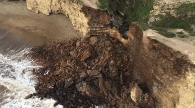
Note that these rock arches won’t last forever. The same erosional forces of nature that created them will eventually take them down. Point Reyes National Seashore lost one in 2015 when the span at Arch Rock Beach collapsed. Unfortunately people were on the arch at the time and one person was killed. Another rock arch crumbled down at Tennessee Beach in Marin County in 2012. A photographer at the beach was lucky enough to capture this rare event as it happened (link). Dinosaur Park in Pismo Beach also lost a unique rock arch in recent years. Even though we are losing arches, it is possible that erosion will create new ones in our lifetimes.

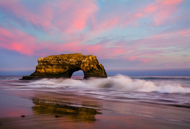
The arch at Natural Bridges State Beach is probably the most photographed of California’s arches. It is a beautiful spot with easy access in Santa Cruz.

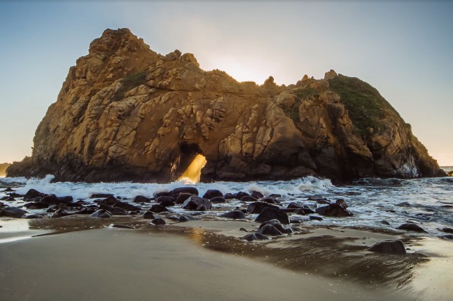
Pfeiffer Beach in Big Sur is also frequently photographed. Professional photographers set up their tripods to catch the sun’s last rays as they pass through the opening in the huge rock that towers over the beach.

Many of the rock arches of California are less-known, but equally photogenic at the right time of day and from the right location. You just have to seek them out and be patient for the right shot.
California’s arches have descriptive names like Elephant Rock, The Keyhole, Jug Handle, The Kissing Rock, and of course Arch Rock (so creative).

Check tide tables before you go and consider visiting the beaches at low tide. Several of these arches are only accessible when the tide is out. In some cases secret beaches can be found by going through the arches at low tide.

See the list below of all the beaches on the California coast that have rock arches to discover. These beaches are listed from south to north.
Beaches on this list
-
No Surf Beach
The San Diego area beach known as “No Surf Beach” is located between Hill and Froude Streets below Sunset Cliffs Boulevard in the Sunset Cliffs neighborhood. There is a short steep […]
-
La Jolla Cove Beach
La Jolla Cove Beach is located at the northeast end of Ellen Browning Scripps Park in La Jolla. This beach is protected by a rocky point which blocks waves rolling […]
-
La Jolla Caves Beach
La Jolla Caves Beach is a hidden rocky beach between La Jolla Cove and La Jolla Shores Beach. During low tides you can walk here from La Jolla Shores, but […]
-
Three Arch Bay Beach
Three Arch Bay Beach is on Mussel Cove in the private gated community of Three Arch Bay in South Laguna Beach. Mussel Cove is walled off on both ends by […]
-
Thousand Steps Beach
Thousand Steps Beach is one of the largest beaches in south Laguna Beach, CA. It’s a wide sandy beach with volleyball courts, restrooms, and tide pools and even caves to […]
-
Totuava Beach
Totuava Beach is a locally-known cove between Thousand Steps Beach and Table Rock Beach in Laguna Beach, CA. Location reference points along South Coast Highway are the Laguna Lido condos […]
-
Table Rock Beach
Table Rock Beach is a locally-known tucked away beach in south Laguna Beach, CA. This is an excellent sandy beach in a deep cove with homes high above. Rocks of […]
-
Middle Man Cove
Middle Man Cove is the name given to the beach area between Goff Cove Beach and Treasure Island Beach below the Montage Resort in Laguna Beach. This is a small […]
-
Pearl Street Beach
Pearl Street Beach is located below a stairway that begins at the west end of Pearl Street in Laguna Beach. Pearl Street ends at Ocean Way just one block off […]
-
Little Corona Del Mar Beach
Little Corona Del Mar Beach is a popular small beach at the end of a ravine called Buck Gully in the Newport Beach neighborhood of Corona Del Mar. This is […]
-
Sacred Cove
Sacred Cove Beach is part of Abalone Cove Shoreline Park in the city of Rancho Palos Verdes. This deep cove is bookended by two prominent points, Portuguese Point and Inspiration […]
-
Abalone Cove Beach
Abalone Cove Beach can be discovered below the parking lot at Abalone Cove Shoreline Park in the city of Rancho Palos Verdes. The bluffs in the park are protected in […]
-
El Matador State Beach
El Matador Beach is one of three beaches within Robert H. Meyer Memorial State Beach. El Matador is the most popular of the three and the closest to Malibu. The […]
-
Leo Carrillo State Park – South Beach
South Beach at Leo Carrillo State Park is a sandy spot near the mouth of a creek that flows out (rarely) from Arroyo Sequit. This dry wash drains part of […]
-
Mugu Beach
Mugu Beach is just north of Mugu Rock in along Pacific Coast Highway in southern Ventura County. This is one of several beaches along a five-mile stretch of coastline in […]
-
Dinosaur Caves Park
Dinosaur Caves Park is a family-friendly park in the Shell Beach area of Pismo Beach, CA. The park has open grass areas, picnic tables, walking paths, ocean overlooks, and an […]
-
Margo Dodd Park Beach
Margo Dodd Park is a small patch of grass on the bluff in the Shell Beach neighborhood of Pismo Beach, CA. A gazebo, two picnic tables, and several benches look […]
-
Pirate’s Cove Beach
Pirate’s Cove is a well-known clothing optional beach between Avila Beach and the Shell Beach area of Pismo Beach, CA. This south-facing cove is somewhat protected from the weather and […]
-
Cave Landing Beach
Cave Landing Beach is a hidden and hard-to-reach beach below Cave Landing in Avila Beach CA. Most of the visitors to the Cave Landing parking lot will head down the […]
-
Point Buchon Trail Beaches
South of Montana de Oro State Park there are beaches and trails on Diablo Canyon Power Plant lands which are administered by Pacific Gas & Electric. To see the bluffs […]
-
Coon Creek Beach – Montana de Oro State Park
Coon Creek Beach is the southernmost beach in Montana de Oro State Park. There is no access to the beach from the state park, but where there’s a will there’s […]
-
Julia Pfeiffer Burns State Park
Julia Pfeiffer Burns State Park on the Big Sur Coast is home to iconic McWay Falls. It’s just a short walk out on a trail to an overlook where many […]
-
Pfeiffer Beach
Pfeiffer Beach in the Big Sur area is definitely off the beaten path, but well worth the drive. Just south of Big Sur Station on Highway 1 there is unsigned […]
-
Little Sur River Beach
Little Sur River Beach is a picturesque beach on the rugged coast between Big Sur and Carmel-by-the-Sea. This is a sandy beach with dunes, drift logs, and steep mountains behind […]
-
Point Lobos SNR – China Cove
China Cove is an emerald green cove with a tiny pocket beach in Point Lobos State Natural Reserve near Carmel, CA. It’s a narrow deep sandy beach surrounded by rock […]
-
Perkins Park
Perkins Park in Pacific Grove is the beachfront park along Ocean View Boulevard between Lover’s Point Park and the tip of Point Pinos. The park is nearly a mile long […]
-
Seabright Beach
Seabright Beach is a popular sandy beach next to Santa Cruz Main Beach in Santa Cruz. It is on state-owned property in that is part of Twin Lakes State Beach. […]
-
Its Beach
Its Beach is the name of the south-facing beach below the bluff on the west side of Point Santa Cruz in Santa Cruz, CA. Lighthouse Field State Beach manages the […]
-
Natural Bridges State Beach
Natural Bridges State Beach is named for the natural arch in the huge rock located in the shore break here. This is one of the most photographed beach icons in […]
-
Hole-in-the-Wall Beach
Hole-in-the-Wall Beach is located immediately south of Panther Beach between Santa Cruz and the town of Davenport. The only access to Hole in the Wall Beach is by walking south […]
-
Panther Beach
Panther Beach is a popular sandy beach north of Santa Cruz near the hamlet of Davenport. It’s part of the Coast Dairies State Park land acquisition and will eventually be […]
-
Davenport Cove & Shark Fin Beach
This is a sandy beach in a small but deep cove south of the town of Davenport. Davenport Cove is locally known by several different names including Shark Fin Cove […]
-
Pescadero State Beach – South Beach
Pescadero State Beach has a wide beach, large dunes, rocky coves, a rock arch, a protected lagoon, and extensive wetlands. This state park has two distinct beach areas that are […]
-
Martins Beach
Martins Beach is open again! Recently the US Supreme Court decided not to hear the case of Martins Beach so the lower court decision stands and the property owner will […]
-
Mussel Rock Park Beach
Mussel Rock Park is made up of a lot of trails connecting to paragliding launch points on a hillside in south Daly City. The shoreline below the park is bouldery […]
-
Sutro Baths
The ruins of the Sutro Baths are an historic site on the western waterfront of San Francisco. In March of 1896 these elaborate privately-owned saltwater and freshwater pools opened to […]
-
Point Bonita Lighthouse
Point Bonita Lighthouse is out on the rocky point on the north side of the entrance to San Francisco Bay. There is no beach access from this point, but there […]
-
South Rodeo Beach
South Rodeo Beach is a small beach in a secluded cove south of Rodeo Beach in the Marin Headlands. It has a reputation as a clothing-optional beach. At low tide you […]
-
Arch Rock Beach
Arch Rock Beach is below the Arch Rock Overlook in Point Reyes National Seashore. In March of 2015 the arch collapsed and took the middle part of the overlook down […]
-
Sculptured Beach
Sculptured Beach is a remote beach in the southern portion of Point Reyes National Seashore. The beach is accessible by walking or mountain biking on the Coast Trail from Point […]
-
Bodega Head Beach
Bodega Head is the prominent rocky point that protects Bodega Harbor from the west. This large point has a rugged coastline that is exposed to strong waves and cool damp […]
-
Arched Rock Beach
Arched Rock Beach is named for the big rock with a hole in it that is visible to the north. The rock is actually right next to Marshall Gulch Beach, […]
-
Blind Beach
Blind Beach is located south of Jenner and the Russian River in Sonoma County. It’s a long narrow beach that is great for beachcombing and fishing. Offshore is a large […]
-
Jenner Beach
Jenner Beach is the main beach at the north side of the Russian River mouth in the town of Jenner. This driftwood strewn beach can be accessed via steep paths […]
-
Hearn Gulch Beach
Hearn Gulch Beach in Mendocino County is in the deep protected cove called Saunders Landing, an old schooner mooring spot for lumber shipments back in the 1800’s. The beach is […]
-
Stornetta Public Lands
Stornetta Public Lands is an open area next to the ocean north of the town of Point Arena. These lands are managed through a partnership with the Bureau of Land […]
-
Greenwood State Beach
Greenwood State Beach is located in the tiny town of Elk where Greenwood Creek flows into the ocean. Greenwood was the name of Elk back in the logging times of […]
-
Navarro Beach
Navarro Beach is located at the mouth of the Navarro River in Mendocino County. It’s part of Navarro River Redwoods State Park, a long narrow park along the Navarro River […]
-
Navarro Point Preserve
Navarro Point Preserve is just north of the beach at the Navarro River mouth in Mendocino County. Mendocino Land Trust acquired these prairie lands on the headlands west of Highway […]
-
Little River Blowhole
The Little River Blowhole is a natural feature near the shoreline in Little River, CA. The waves from the ocean roll in through a rock tunnel and have created a […]
-
Portuguese Beach
Portuguese Beach is on Mendocino Bay on the south side of town in Mendocino. The visitor center for Mendocino Headlands State Park is in the Historic Ford House on the […]
-
Mendocino Headlands Beaches
The Mendocino Headlands along Heeser Drive in Mendocino California has several stunning coves tucked below the bluff. Most are best photographed from above even though the eager adventurer could probably […]
-
Russian Gulch State Park
Russian Gulch State Park, north of Mendocino, has a sandy beach below the Highway 1 bridge where Russian Gulch Creek flows into a narrow cove. Kids can play in the safe […]
-
Seaside Beach
Seaside Beach is just north of MacKerricher State Park where Seaside Creek sometimes flows through the sand to the ocean. A rock sticks up out of the sand at the […]
-
Chadbourne Gulch Beach
Chadbourne Gulch Beach, known locally as Blues Beach, is just south of the small Mendocino County town of Westport. The creek in Chadbourne Gulch flows across the middle portion of […]
-
Eddie White Beach at Westport Headlands
Westport Headlands Park is a nine acre public open-space right in the town of Westport along the Mendocino Coast. The beach below the park is locally known as Eddie White Beach. […]
-
Pete’s Beach
Westport-Union Landing State Beach has two public beaches separated by the private beach at the Westport Beach RV Park & Campground. The southern beach is a little-known California State Beach […]
-
Hardy Creek Beach
Hardy Creek Beach in Mendocino County is located where Highway 1 turns inland and heads north never to return to the coast. The beach is in a small cove where […]
-
Needle Rock Beach
Needle Rock Beach is near the Needle Rock Visitor Center at Sinkyone Wilderness State Park. From the visitor center walk back on the road a bit to the old wooden […]
-
Mattole Road Beaches
There are many unnamed beaches along the remote Mattole Road near the town of Petrolia in Humboldt County. These beaches are seldom visited. Access to them isn’t obvious but where […]
-
College Cove
College Cove Beach is in the north cove of Trinidad State Beach in the small town of Trinidad. College Cove has a more secluded feel than the main state beach […]
-
Martin Creek Beach
Martin Creek Beach might be the most hidden beach in Northern California. Except for locals this beach is pretty much unknown, yet it is a wonderful spot to visit. It […]
-
Freshwater Lagoon Beach
Freshwater Lagoon is the northernmost of four separate lagoons in Humboldt Lagoons State Park, but the ocean beach side of Freshwater Lagoon is situated within the boundary of Redwood National […]
-
Damnation Creek Trail Beach
Damnation Creek Beach is a remote rocky stretch of coastline in Del Norte Coast Redwoods State Park. This shoreline isn’t a wide sandy beach, but it still works well as […]
-
Point St. George Beach
Point St. George is a prominent rocky point about three miles north of Crescent City. The Point is where the St. George Reef Lighthouse keepers lived when they were ashore […]